
Ten kilometres north of Fort Portal, there is an abyss. Somewhere beyond the trading centre of Harugongo, the highland comes to a sudden end, disappearing at a spectacular slope down to Semliki valley a 1.000 m below. The Semliki river is coming from the DR Congo and flowing into Lake Albert, marking the border between the DR Congo and Uganda on its last kilometres. The only settlement in the valley worth mentioning is the fishing village of Ntoroko at the southern tip of Lake Albert. Because of considerable parts of the valley, all the way to the lake, being protected as Toro-Semliki Wildlife Reserve – and self-organized budget travellers being ignored or looked at as a pain in the ass by the Ugandan tourism and National Park system, even by using the road to Ntoroko or staying at the village, one would have to pay the full entrance fee of 35$/24h.
Etwa zehn Kilometer nördlich von Fort Portal tut sich ein Abgrund auf. Nach der Ortschaft Harugongo endet irgendwann ganz unvermittelt das Hochland und stürzt entlang eines spektakulären Abhangs etwa 1.000 m in die Tiefe, hinab ins Tal des Semliki, der von der DR Kongo kommend dort in den Albertsee mündet. Auf seinen letzten Kilometern bildet der Semliki-Fluss die Grenze zwischen der DR Kongo und Uganda. Einzige nennenswerte Ortschaft ist das Fischerdorf Ntoroko an der Südspitze des Albertsees, doch da ein Großteil des Tals bis hin zum See als Toro-Semliki Wildlife Reserve unter Schutz gestellt ist – und budgetgebundene Individualreisende vom ugandischen Tourismus- und Nationalpark-System bestenfalls ignoriert oder als notwendiges Übel betrachtet werden, fällt die Parkeintrittsgebühr (anders als im einen oder anderen Reiseführer beschrieben) von 35$/24 Stunden schon bei einer Fahrt mit dem Minibus nach Ntoroko und beim Aufenthalt im Dorf an.


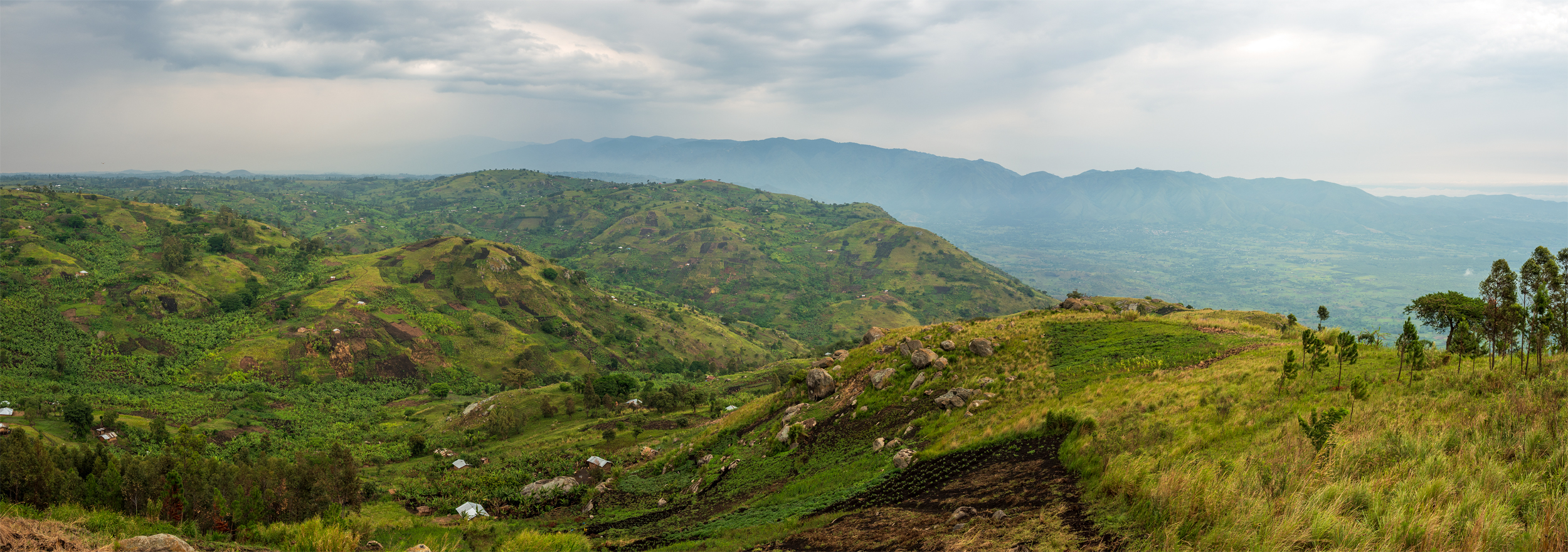
After the rain, of which there is a lot around Fort Portal, the track from Harugongo to the viewpoint is a challenge, to put it mildly. The nearly black volcanic soil is dense, heavy and fertile. There are coffee and tea plantations mixed with the small local farms as far as the eye can see. Equipped with a map and a guide book I was trying to find the way and explain it to Andrew, our driver, who didn´t know the place. We had decided against the experience of a Boda ride through the mud, because it had rained the whole night, and even on our way to the viewpoint, it started to drizzle regularly. That viewpoint is not well-known, not even in the surrounding villages but in the end, we managed to gently crash Andrew´s Toyota saloon car into the slope that finally led us to the viewpoint.
Wenn es geregnet hat, was es um Fort Portal eine Menge tut, ist die Piste von Harugongo bis zum Aussichtspunkt eine Herausforderung – gelinde ausgedrückt. Die fast schwarze vulkanische Erde ist schwer und fruchtbar, soweit das Auge reicht Tee- und Kaffeeplantagen sowie die Felder der Einheimischen. Mit Karte und Reiseführer bewaffnet musste ich Andrew, unserem Taxifahrer, den Weg erklären, er selbst kannte den Ort nicht. Wir hatten auf das Erlebnis einer längeren Bodafahrt im Schlamm verzichtet, weil es die ganze Nacht durchgeregnet hatte und es auch auf dem Weg dorthin immer wieder zu nieseln begann. Insgesamt ist der Aussichtspunkt eher unbekannt, selbst in den umliegenden Dörfern, aber am Ende schlitterten wir in Andrews Toyota-Limousine doch in den Hang, der die letzte Hürde darstellte.


There was a young man guarding the mobile communications system on top of the hill and feeling responsible for the viewpoint as well. On a muddy and slippery path, he guided us up the hill till we reached the buzzing antenna – and the huge Coca-Cola bottle made of plastic. Looking forward to a future flow of visitors and in order to secure a leading position on the market, the Coca-Cola Company had put up that bottle-shaped stall for selling their Sodas. I would have bought some, but two lousy backpackers are not enough for making business. However, the guard told us that there is an investor interested in building a lodge up there. It is the perfect location for an accommodation, with a spectacular view down to the valley, to the western extension of the Great African Rift valley and Lake Albert.
Hinaufgeführt wurden wir von einem jungen Mann, der die Mobilfunkanlage auf der Spitze des Hügels bewachte und sich dadurch irgendwie auch für den dort gelegenen Aussichtspunkt verantwortlich fühlte. Es ging einen matschigen Feldweg steil hinauf, bis wir die surrende Antenne erreichten – und die riesige Plastik-Colaflasche. Die Coca-Cola-Company hat dort, in Erwartung der sich irgendwann einstellenden Besucherströme und um sich frühzeitig den potentiellen Markt zu sichern, einen Verkaufsstand für die firmeneigenen Produkte in Form einer großen Colaflasche errichtet. Ich hätte schon was genommen, aber zwei popelige Backpacker reichen natürlich nicht aus, um dort wirklich etwas zu verkaufen. Allerdings berichtete uns der Mobilfunkwächter, dass ein Investor Interesse daran zeige, dort oben eine Lodge zu bauen. Es wäre der ideale Ort, mit einem spektakulären Blick direkt hinab in den großen Afrikanischen Grabenbruch, auf den westlichen Arm des Rift Valleys und den Albertsee.

2 Gedanken zu “Semliki Valley”